


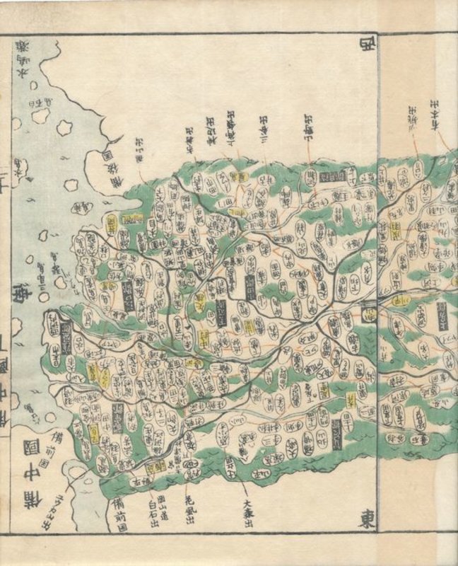


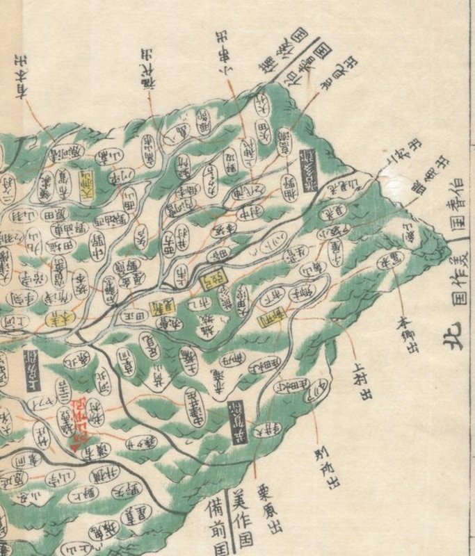

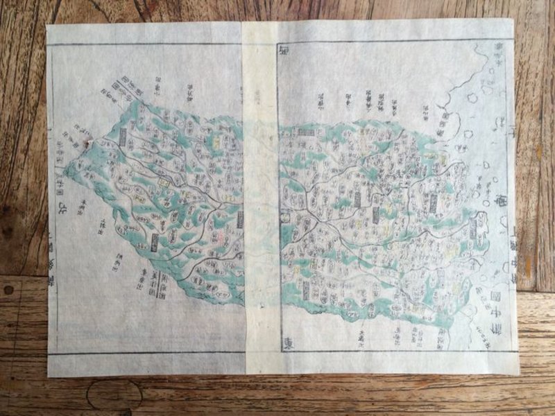
Map of Bitchū (備中国, Bitchū no kuni), taken from Kokugun Zenzu / Atlas of Japan (De luxe version)
Japan: 1830. A map of the Bitchū (備中国, Bitchū no kuni) is a former province of Japan, located on the Japanese internal sea of west Honshu. it occupied the area west of the present day prefecture Okayama. Bitchu is next to the provinces Hoki, Mimasaka, Bizen and Bingo. is a former province of Japan, on the island Awaji, between the islands Honshu and Shikoku. it is part of the former region Nankaidō and is in the present day prefecture Hyogo. it is also called Tanshu (淡州). Printed on two pages (fixed together) on rice paper. Produced as part of Kokugun Zenzu (Atlas of Japan), mapped and prepared by Ino Tadataka, and compiled after his death by Motonobu Aoo and Toshiro Eirakuua. This map is taken from the De-Luxe version of the map (the standard version was slightly smaller and printed on thinner paper). Contemporary colouring. Map measures 215 by 320mm (8½ by 12½ inches). A very nice clean copy. Strong colouring. No chips or tears. Ino Tadataka (1745-1818) was a Japanese surveyor and cartographer and is considered to be one of the fathers of modern Japan. Ino Tadataka was born in Kujukuri, a coastal village in Kazusa Province (Chiba Prefecture) at 17 he was adopted into the prosperous Ino clan. The Ino family were wealth rice merchantS and saki brewers based in Sawara (now a district of Katori, Chiba), a town in Shimo-Usa Province. Ino Tadataka served the family interests for nearly thirty-two years before turning his interests to mathematics, astronomy, and cartography. He moved to Edo (modern Tokyo) and there apprenticed himself to Takahashi Yoshitoki, a specialist in astronomy under the Tokugawa Shogunate. After five years of study he petitioned the Shogun for permission to map the coastline of Japan using modern techniques and his own money. The Shogun approved and Tadataka spent the next seventeen years surveying the country on foot. This monumental work resulted in a map and subsequent atlas of such extraordinary accuracy and detail that would be the definitive mapping of Japan for the next 100 years. The maps and atlases for which Ino Tadataka would be forever known were compiled by his friends and family and published approximately three years after his death. By the late 19th century Ino Tadataka's maps had become the standard for Japanese cartography and were avidly collected by wealthy merchants and bureaucrats throughout Japan. One such, a functionary in the Imperial household, actually managed to collect most of Ino Tadataka's surviving work which he stored in the Royal Palace. When the Palace was destroyed by fire in 1814 most of this prized collection went with it. Une carte du Bitchū (備中国, Bitchū no kuni) est une ancienne province du Japon, située sur la mer intérieure japonaise de l'ouest Honshu. il occupait la zone à l'ouest de l'actuelle préfecture d'Okayama. Bitchu est à côté des provinces Hoki, Mimasaka, Bizen et Bingo. est une ancienne province du Japon, sur l'île Awaji, entre les îles Honshu et Shikoku. il fait partie de l'ancienne région de Nankaidō et se trouve dans l'actuelle préfecture de Hyogo. on l'appelle aussi Tanshu (淡州). Imprimé sur deux pages (fixées ensemble) sur papier de riz. Produit dans le cadre de Kokugun Zenzu (Atlas du Japon), cartographié et préparé par Ino Tadataka, et compilé après sa mort par Motonobu Aoo et Toshiro Eirakuua. Cette carte est tirée de la version De-Luxe de la carte (la version standard était légèrement plus petite et imprimée sur du papier plus fin). Coloration contemporaine. La carte mesure 215 par 320 mm (8½ par 12½ pouces). Un très bel exemplaire propre. Coloration forte. Pas d'éclats ni de déchirures. Ino Tadataka (1745-1818) était un géomètre et cartographe japonais et est considéré comme l'un des pères du Japon moderne. Ino Tadataka est né à Kujukuri, un village côtier de la province de Kazusa (préfecture de Chiba) à 17 ans, il a été adopté par le prospère clan Ino. La famille Ino était constituée de riches marchands de riz et de brasseurs de saki basés à Sawara (aujourd'hui un district de Katori, Chiba), une ville de la province de Shimo-Usa. Ino Tadataka a servi les intérêts de la famille pendant près de trente-deux ans avant de se tourner vers les mathématiques, l'astronomie et la cartographie. Il a déménagé à Edo (Tokyo moderne) et y a fait son apprentissage chez Takahashi Yoshitoki, un spécialiste en astronomie sous le shogunat Tokugawa. Après cinq années d'études, il a demandé au shogun la permission de cartographier le littoral du Japon en utilisant des techniques modernes et son propre argent. Le shogun approuva et Tadataka passa les dix-sept années suivantes à arpenter le pays à pied. Ce travail monumental a abouti à une carte et à un atlas ultérieur d'une précision et de détails extraordinaires qui seraient la cartographie définitive du Japon pour les 100 prochaines années. Les cartes et les atlas pour lesquels Ino Tadataka serait à jamais connu ont été compilés par ses amis et sa famille et publiés environ trois ans après sa mort. À la fin du XIXe siècle, les cartes d'Ino Tadataka étaient devenues la norme pour la cartographie japonaise et étaient avidement collectées par de riches marchands et bureaucrates dans tout le Japon. L'un d'entre eux, un fonctionnaire de la maison impériale, a en fait réussi à rassembler la plupart des œuvres survivantes d'Ino Tadataka qu'il a stockées dans le palais royal. Lorsque le palais a été détruit par un incendie en 1814, la plupart de cette précieuse collection l'accompagnait.