- Category = British Topography,European Travel & Exploration,Maps & Atlases,Polar,Rest of the World,Travel Guides
-
 De Vernieuwde Waag op Den Dam. New Weigh House on The Dam Square, Amsterdam.
Book ID: 4300More details Price: £125.00
De Vernieuwde Waag op Den Dam. New Weigh House on The Dam Square, Amsterdam.
Book ID: 4300More details Price: £125.00 -
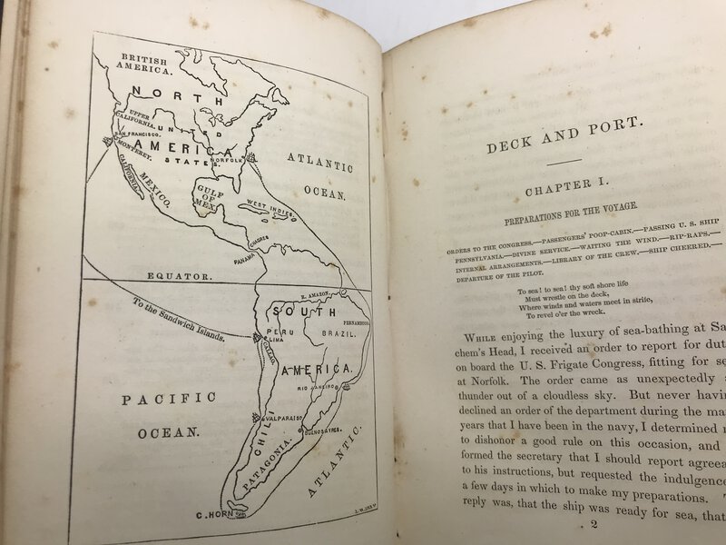
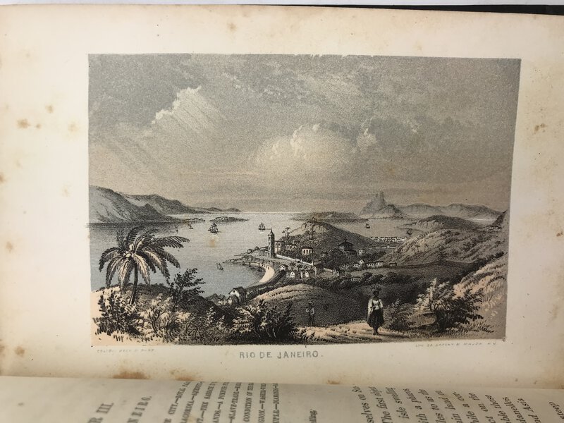
 Deck and Port; or, Incidents of a Cruise in the United States Frigate Congress to California.
Book ID: 2968More details Price: £100.00
Deck and Port; or, Incidents of a Cruise in the United States Frigate Congress to California.
Book ID: 2968More details Price: £100.00 -
 Douglas Gordon k.364. A journey by train.
Book ID: 3774More details Price: £65.00
Douglas Gordon k.364. A journey by train.
Book ID: 3774More details Price: £65.00 -
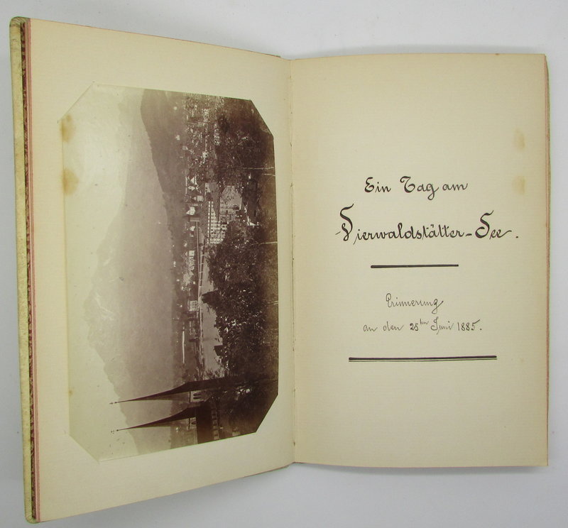
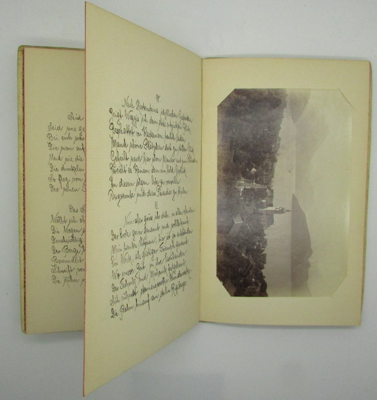
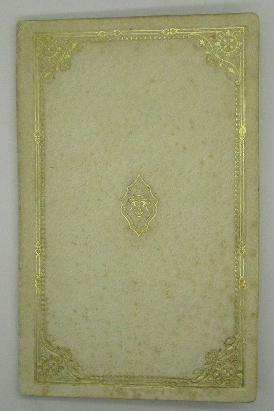
 Ein Tag am Vierwaldstättersee - Erinnerung.
A Manuscript travelogue / Poem with 8 silver print photographs.
Ein Tag am Vierwaldstättersee - Erinnerung.
A Manuscript travelogue / Poem with 8 silver print photographs.
Lucerne: Manuscript, 1885. Original manuscript poem / travelogue, recounting an excursion on the Vierwaldstättersee (Lake Lucerne) in 1885. Eight silver print photographs are tipped in amongst the text. Cream embossed leather binding. Gilt detail to the front board. Attractive gilt and brown end papers. Unpaginated, but 40 stanza's in a neat German hand. The leather boards are clean and tidy, with a little darkening / foxing to the skin. Internally clean and tidy throughout. 200 x 130 mm (7¾ x 5 inches).
Book ID: 2066More details Price: £150.00 -
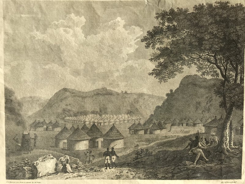
 Engraved plate - A View of Kamalia
London: W. Bulmer and Co. for the author; and sold by G. and W. Nicol, 1799. Original loose plate from Mungo Park's, Travels in the Interior Districts of Africa: performed under the direction and patronage of the African Association, in the years 1795, 1796, and 1797. With an appendix, containing geographical illustrations of Africa. By Major Rennell. (London, 1799). This found facing p. 252 was taken from a drawing that was based on a sketch made by Park. Darkening / foxing to the top edge of the margin. Overall good - perfect for framing. Blank to verso. 215 x 270 mm (8½ x 10¾ inches).
Book ID: 3012More details Price: £30.00 -
![Erinnerung an England. Den Katholiken Deutschlands Gewidmet. by [ANON]](https://images.vialibri.net/production/20/1310-1---200.JPG?v=1531506997) Erinnerung an England. Den Katholiken Deutschlands Gewidmet.
[Memories of England, dedicated to the Catholics of Germany]
Erinnerung an England. Den Katholiken Deutschlands Gewidmet.
[Memories of England, dedicated to the Catholics of Germany]
Edition: First Edition
Munchen / Munich: 1840. Blue / grey paper covers. Sewn. Heavy rag paper. Printed in Gothic script. Woodcut illustration to the title page. Text in German throughout. An account of a tour of England. It seems mainly to have been visits to Catholics, and much of the text is commenting on religious matters. The book ends with a litany / prayer for England. 48 pp.
Condition: The covers are clean and tidy, with just a touch of marking. Likewise, the text is clean throughout. An attractive copy.
Book ID: 1310More details Price: £6.00 -
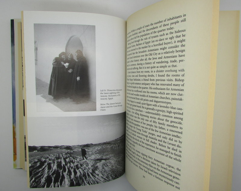
 From the Holy Mountain.
A Journey Among the Christians of the Middle East.
From the Holy Mountain.
A Journey Among the Christians of the Middle East.
London: Harper Collins, 1997. First edition. Signed by author on the title page. In near fine unclipped dust jacket. Decorative endpapers. Under dust jacket the cloth boards are spotless and the gilt title is bright. No foxing. Internally too everything is clean and bright. "It is a rich and gripping blend of history and spirituality, adventure and politics, laced with a thread of black comedy." The author retraces the footsteps of monks John Moschos and his pupil Sophronius the Sophist through eastern Turkey, the ruins of Beirut, the West Bank and southern Egypt. x, 484 pp.
Book ID: 2228More details Price: £30.00 -
![Geographie Moderne: Barbarie/ Desert de Barbarie / Nigritie by CLOUET, J.B.L. [Jean, Baptiste, Louis. L'Abbe].](https://images.vialibri.net/production/20/1755-1---200.jpg?v=1531508298) Geographie Moderne: Barbarie/ Desert de Barbarie / Nigritie
A hand coloured map of the Sahara desert & North Africa - Also showing Southern Europe
Book ID: 1755More details Price: £85.00
Geographie Moderne: Barbarie/ Desert de Barbarie / Nigritie
A hand coloured map of the Sahara desert & North Africa - Also showing Southern Europe
Book ID: 1755More details Price: £85.00 -
![Geographie Moderne: De la Guinee / Du Congo / De la Cafrerie / Île de de Madagascar by CLOUET, J.B.L. [Jean, Baptiste, Louis. L'Abbe].](https://images.vialibri.net/production/20/1756-1---200.jpg?v=1531507725) Geographie Moderne: De la Guinee / Du Congo / De la Cafrerie / Île de de Madagascar
A hand coloured map of the African coast - Upper Guinea, Madagascar, the Gold Coast etc:
Book ID: 1756More details Price: £90.00
Geographie Moderne: De la Guinee / Du Congo / De la Cafrerie / Île de de Madagascar
A hand coloured map of the African coast - Upper Guinea, Madagascar, the Gold Coast etc:
Book ID: 1756More details Price: £90.00 -
![Geographie Moderne: Empire du Mogol / Siam / Cochin Chine & Camboja by CLOUET, J.B.L. [Jean, Baptiste, Louis. L'Abbe].](https://images.vialibri.net/production/20/1753-1---200.jpg?v=1531508852) Geographie Moderne: Empire du Mogol / Siam / Cochin Chine & Camboja
A hand coloured map of the Mogul Empire, India & South East Asia (Thailand & Vietnam).
Book ID: 1753More details Price: £90.00
Geographie Moderne: Empire du Mogol / Siam / Cochin Chine & Camboja
A hand coloured map of the Mogul Empire, India & South East Asia (Thailand & Vietnam).
Book ID: 1753More details Price: £90.00 -
![Gezigt [Gezicht] op de Oude Kerk by BEIJER, Jan de.](https://images.vialibri.net/production/20/4291-01---200.JPG?v=1709140251) Gezigt [Gezicht] op de Oude Kerk
van buiten aan de Zuidzyde
Book ID: 4291More details Price: £125.00
Gezigt [Gezicht] op de Oude Kerk
van buiten aan de Zuidzyde
Book ID: 4291More details Price: £125.00 -
 Gezigt Langs Het Rokin, op de Nieuwe - Zyds - Kapel en Beurs
1765. Engraved by J. Folkema. An attractive view of the Amsterdam Stock Exchange (built in 1611 by Hendrick de Keyser) the Nieuwezijds Kapel can be seen to the left. Engraving is 28cm x 37cm. Sheet is 43cm x 52cm. A nice clean copy, with just a touch of handling. Uncoloured.
. Gravure de J. Folkema. Une belle vue de la Bourse d'Amsterdam (construite en 1611 par Hendrick de Keyser). On aperçoit la Nieuwezijds Kapel à gauche. La gravure mesure 28 cm x 37 cm. La feuille mesure 43 cm x 52 cm. Un bel exemplaire propre, avec juste un peu de manipulation. Non coloré.
Book ID: 4301More details Price: £125.00 -
 Gezigt op het Stadhuis
langs de noorzyde en van agteren, en op den onvolbouwden tooren der Nieuwe Kerke
Gezigt op het Stadhuis
langs de noorzyde en van agteren, en op den onvolbouwden tooren der Nieuwe Kerke
Amsterdam: Isaak Tirion, 1765. An attractive and uncommon view of the City Hall, by Liender after an anonymous artist. Published by Isaak Tirion as part of Jan de Wanenaar's "Amsterdam in its rise, growth, histories,..," ("Amsterdam in zyne opkomst, aanwas, geschiedenissen,.etc.,"). engraved area is 29cm x 37cm. Page is 43cm x 52cm. First edition. Good strong impression, and nice clean plate. A very good copy. Fractionally darkened to the edges.
Book ID: 4307More details Price: £125.00 -
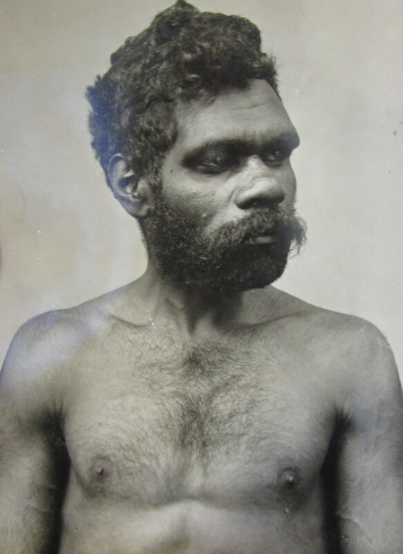
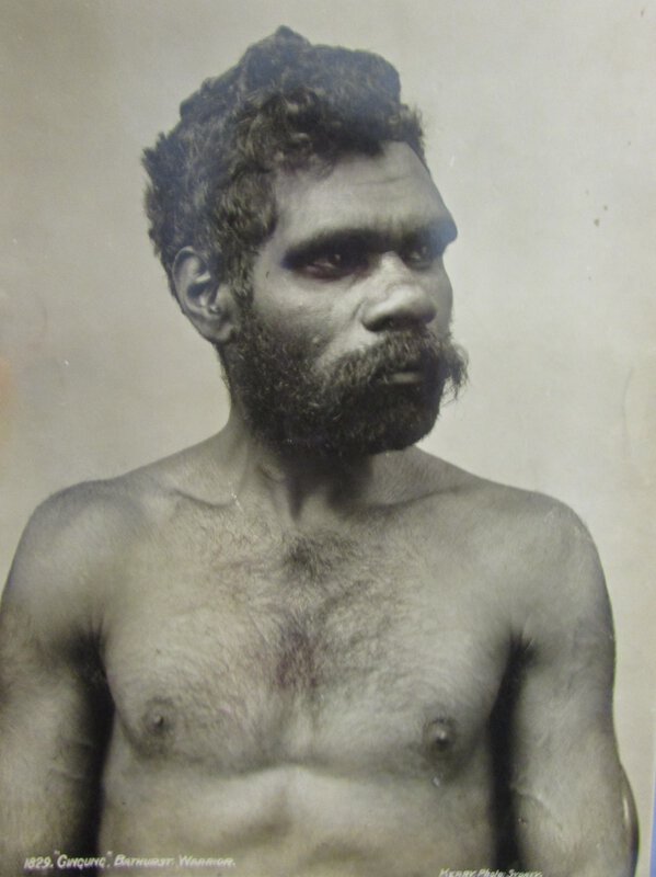
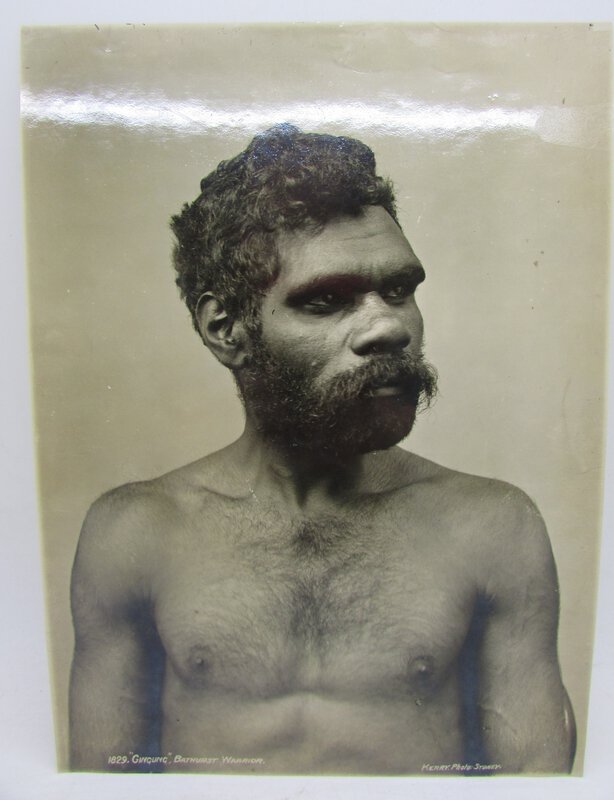
 'Gingung' an Australian Aboriginal man
Book ID: 2748More details Price: £200.00
'Gingung' an Australian Aboriginal man
Book ID: 2748More details Price: £200.00 -
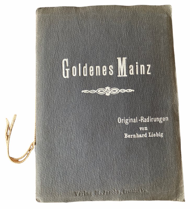
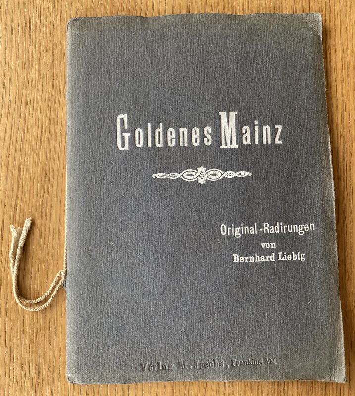
 Goldenes Mainz - Original-Radierungen
Frankfurt: M. Jacobs. First edition. Circa 1900. Twelve beautiful engravings of Mainz by Liebig. Bound in soft covers with white printed titles. Original cord ties. Handmade paper. Each of the engravings are protected by tissue guards. Good strong impressions, in excellent condition. Complete. 230 x 165 mm (9 x 6½ inches).
Book ID: 3158More details Price: £100.00 -
 Graphic Illustrations of the Most Prominent Features of the French Capital;
With Characteristic Figures in the Foregrounds Comprised in Twelve Stroke Engravings, From Accurate Designs Taken in Paris During the Imperial Reign of Buonaparte
Book ID: 4090More details Price: £2,000.00
Graphic Illustrations of the Most Prominent Features of the French Capital;
With Characteristic Figures in the Foregrounds Comprised in Twelve Stroke Engravings, From Accurate Designs Taken in Paris During the Imperial Reign of Buonaparte
Book ID: 4090More details Price: £2,000.00 -
 Gravure 'Voyages par la Moscovie, en Perse, et aux Indes Orientales'.
Book ID: 2316More details Price: £30.00
Gravure 'Voyages par la Moscovie, en Perse, et aux Indes Orientales'.
Book ID: 2316More details Price: £30.00 -
![[GREAT BRITAIN] – HEDENDAAGSCHE HISTORIE, Of Tegenwoordige Staat Van Groot Brittannie. [Vol. I-II] by [SALMON, Thomas.] & TIRION, Isaak](https://images.vialibri.net/production/20/3701-01---200.jpg?v=1671543216) [GREAT BRITAIN] – HEDENDAAGSCHE HISTORIE, Of Tegenwoordige Staat Van Groot Brittannie. [Vol. I-II]
Vervattende Eene Beschryving van 's Lands Gelegenheid.
Book ID: 3701More details Price: £600.00
[GREAT BRITAIN] – HEDENDAAGSCHE HISTORIE, Of Tegenwoordige Staat Van Groot Brittannie. [Vol. I-II]
Vervattende Eene Beschryving van 's Lands Gelegenheid.
Book ID: 3701More details Price: £600.00 -
 Guide to Fountains Abbey
Plans and Illustrations from photographs by W. Wainwright.
Guide to Fountains Abbey
Plans and Illustrations from photographs by W. Wainwright.
Edition: Reprint
Ripon: W. Harrison & Son (C. Harker), 1922. Pale green paper covers with black titles. Advert for a similar book to the rear panel. This is the Third Edition, with the price One Shilling boldly printed to the front panel. Adverts to the inside covers. Stapled. A nice clean copy. Small stamp with "west lodge, Fountains Abbey" to the front cover - perhaps the then bookshop for the Abbey? Light rusting to the staples, otherwise clean and tidy inside and out. Not a first, but a very early edition of this guide to the Cistercian ruins. Black and white photographs throughout. [x], 48, [x], pp.
Book ID: 1252More details Price: £8.00 -
 Histoire des Francais dans L'Inde. Depuis la Fondation de Pondichery.
Jusqu'a la Prise de Cette Ville (1674-1761). Traduction de Mme S, Le Page.
Book ID: 2232More details Price: £125.00
Histoire des Francais dans L'Inde. Depuis la Fondation de Pondichery.
Jusqu'a la Prise de Cette Ville (1674-1761). Traduction de Mme S, Le Page.
Book ID: 2232More details Price: £125.00


![Erinnerung an England. Den Katholiken Deutschlands Gewidmet. by [ANON]](https://images.vialibri.net/production/20/1310-1---800.JPG?v=1531506997)
![Another image of Erinnerung an England. Den Katholiken Deutschlands Gewidmet. by [ANON]](https://images.vialibri.net/production/20/1310-2---800.JPG?v=1531506998)
![Another image of Erinnerung an England. Den Katholiken Deutschlands Gewidmet. by [ANON]](https://images.vialibri.net/production/20/1310-3---800.JPG?v=1531507110)


![Geographie Moderne: Barbarie/ Desert de Barbarie / Nigritie by CLOUET, J.B.L. [Jean, Baptiste, Louis. L'Abbe].](https://images.vialibri.net/production/20/1755-1---800.jpg?v=1531508298)
![Another image of Geographie Moderne: Barbarie/ Desert de Barbarie / Nigritie by CLOUET, J.B.L. [Jean, Baptiste, Louis. L'Abbe].](https://images.vialibri.net/production/20/1755-2---800.jpg?v=1531508180)
![Another image of Geographie Moderne: Barbarie/ Desert de Barbarie / Nigritie by CLOUET, J.B.L. [Jean, Baptiste, Louis. L'Abbe].](https://images.vialibri.net/production/20/1755-3---800.jpg?v=1531507724)
![Another image of Geographie Moderne: Barbarie/ Desert de Barbarie / Nigritie by CLOUET, J.B.L. [Jean, Baptiste, Louis. L'Abbe].](https://images.vialibri.net/production/20/1755-4---800.jpg?v=1531507930)
![Another image of Geographie Moderne: Barbarie/ Desert de Barbarie / Nigritie by CLOUET, J.B.L. [Jean, Baptiste, Louis. L'Abbe].](https://images.vialibri.net/production/20/1755-5---800.jpg?v=1531507977)
![Another image of Geographie Moderne: Barbarie/ Desert de Barbarie / Nigritie by CLOUET, J.B.L. [Jean, Baptiste, Louis. L'Abbe].](https://images.vialibri.net/production/20/1755-6---800.jpg?v=1531506565)
![Geographie Moderne: De la Guinee / Du Congo / De la Cafrerie / Île de de Madagascar by CLOUET, J.B.L. [Jean, Baptiste, Louis. L'Abbe].](https://images.vialibri.net/production/20/1756-1---800.jpg?v=1531507725)
![Another image of Geographie Moderne: De la Guinee / Du Congo / De la Cafrerie / Île de de Madagascar by CLOUET, J.B.L. [Jean, Baptiste, Louis. L'Abbe].](https://images.vialibri.net/production/20/1756-2---800.jpg?v=1531507584)
![Another image of Geographie Moderne: De la Guinee / Du Congo / De la Cafrerie / Île de de Madagascar by CLOUET, J.B.L. [Jean, Baptiste, Louis. L'Abbe].](https://images.vialibri.net/production/20/1756-3---800.jpg?v=1531507990)
![Another image of Geographie Moderne: De la Guinee / Du Congo / De la Cafrerie / Île de de Madagascar by CLOUET, J.B.L. [Jean, Baptiste, Louis. L'Abbe].](https://images.vialibri.net/production/20/1756-4---800.jpg?v=1531507792)
![Another image of Geographie Moderne: De la Guinee / Du Congo / De la Cafrerie / Île de de Madagascar by CLOUET, J.B.L. [Jean, Baptiste, Louis. L'Abbe].](https://images.vialibri.net/production/20/1756-5---800.jpg?v=1531507585)
![Another image of Geographie Moderne: De la Guinee / Du Congo / De la Cafrerie / Île de de Madagascar by CLOUET, J.B.L. [Jean, Baptiste, Louis. L'Abbe].](https://images.vialibri.net/production/20/1756-6---800.jpg?v=1531506567)
![Geographie Moderne: Empire du Mogol / Siam / Cochin Chine & Camboja by CLOUET, J.B.L. [Jean, Baptiste, Louis. L'Abbe].](https://images.vialibri.net/production/20/1753-1---800.jpg?v=1531508852)
![Another image of Geographie Moderne: Empire du Mogol / Siam / Cochin Chine & Camboja by CLOUET, J.B.L. [Jean, Baptiste, Louis. L'Abbe].](https://images.vialibri.net/production/20/1753-2---800.jpg?v=1531507976)
![Another image of Geographie Moderne: Empire du Mogol / Siam / Cochin Chine & Camboja by CLOUET, J.B.L. [Jean, Baptiste, Louis. L'Abbe].](https://images.vialibri.net/production/20/1753-3---800.jpg?v=1531506564)
![Gezigt [Gezicht] op de Oude Kerk by BEIJER, Jan de.](https://images.vialibri.net/production/20/4291-01---800.JPG?v=1709140251)
![Another image of Gezigt [Gezicht] op de Oude Kerk by BEIJER, Jan de.](https://images.vialibri.net/production/20/4291-02---800.JPG?v=1709140252)
![Another image of Gezigt [Gezicht] op de Oude Kerk by BEIJER, Jan de.](https://images.vialibri.net/production/20/4291-03---800.JPG?v=1709140247)
![Another image of Gezigt [Gezicht] op de Oude Kerk by BEIJER, Jan de.](https://images.vialibri.net/production/20/4291-04---800.JPG?v=1709140259)
![Another image of Gezigt [Gezicht] op de Oude Kerk by BEIJER, Jan de.](https://images.vialibri.net/production/20/4291-05---800.JPG?v=1709140257)
![Another image of Gezigt [Gezicht] op de Oude Kerk by BEIJER, Jan de.](https://images.vialibri.net/production/20/4291-06---800.JPG?v=1709140259)
![Another image of Gezigt [Gezicht] op de Oude Kerk by BEIJER, Jan de.](https://images.vialibri.net/production/20/4291-07---800.JPG?v=1709140251)


![[GREAT BRITAIN] – HEDENDAAGSCHE HISTORIE, Of Tegenwoordige Staat Van Groot Brittannie. [Vol. I-II] by [SALMON, Thomas.] & TIRION, Isaak](https://images.vialibri.net/production/20/3701-01---800.jpg?v=1671543216)
![Another image of [GREAT BRITAIN] – HEDENDAAGSCHE HISTORIE, Of Tegenwoordige Staat Van Groot Brittannie. [Vol. I-II] by [SALMON, Thomas.] & TIRION, Isaak](https://images.vialibri.net/production/20/3701-02---800.jpg?v=1671543245)
![Another image of [GREAT BRITAIN] – HEDENDAAGSCHE HISTORIE, Of Tegenwoordige Staat Van Groot Brittannie. [Vol. I-II] by [SALMON, Thomas.] & TIRION, Isaak](https://images.vialibri.net/production/20/3701-03---800.jpg?v=1671543225)
![Another image of [GREAT BRITAIN] – HEDENDAAGSCHE HISTORIE, Of Tegenwoordige Staat Van Groot Brittannie. [Vol. I-II] by [SALMON, Thomas.] & TIRION, Isaak](https://images.vialibri.net/production/20/3701-04---800.jpg?v=1671543242)
![Another image of [GREAT BRITAIN] – HEDENDAAGSCHE HISTORIE, Of Tegenwoordige Staat Van Groot Brittannie. [Vol. I-II] by [SALMON, Thomas.] & TIRION, Isaak](https://images.vialibri.net/production/20/3701-05---800.jpg?v=1671543218)
![Another image of [GREAT BRITAIN] – HEDENDAAGSCHE HISTORIE, Of Tegenwoordige Staat Van Groot Brittannie. [Vol. I-II] by [SALMON, Thomas.] & TIRION, Isaak](https://images.vialibri.net/production/20/3701-06---800.jpg?v=1671543215)
![Another image of [GREAT BRITAIN] – HEDENDAAGSCHE HISTORIE, Of Tegenwoordige Staat Van Groot Brittannie. [Vol. I-II] by [SALMON, Thomas.] & TIRION, Isaak](https://images.vialibri.net/production/20/3701-07---800.jpg?v=1671543232)
![Another image of [GREAT BRITAIN] – HEDENDAAGSCHE HISTORIE, Of Tegenwoordige Staat Van Groot Brittannie. [Vol. I-II] by [SALMON, Thomas.] & TIRION, Isaak](https://images.vialibri.net/production/20/3701-08---800.jpg?v=1671543217)
![Another image of [GREAT BRITAIN] – HEDENDAAGSCHE HISTORIE, Of Tegenwoordige Staat Van Groot Brittannie. [Vol. I-II] by [SALMON, Thomas.] & TIRION, Isaak](https://images.vialibri.net/production/20/3701-09---800.jpg?v=1671543224)