- Category = Maps & Atlases
-
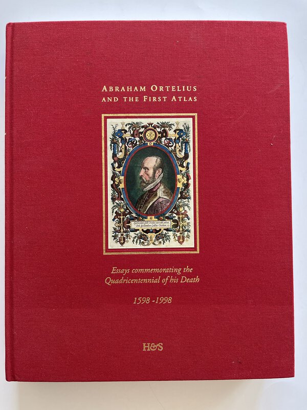
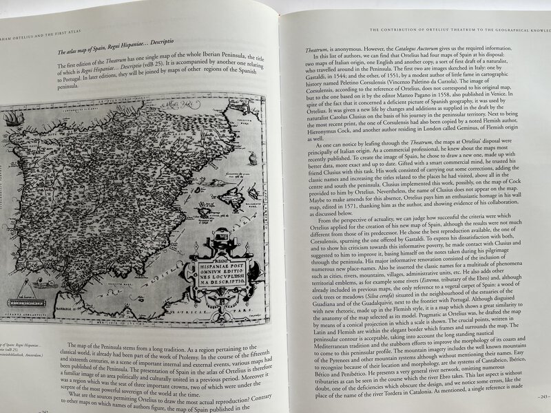
 Abraham Ortelius and the First Atlas. Essays commemorating the Quadricentennial of his Death. 1598 - 1998.
With an introduction by Leon Voet.
Abraham Ortelius and the First Atlas. Essays commemorating the Quadricentennial of his Death. 1598 - 1998.
With an introduction by Leon Voet.
Utrecht: Hes Publishers BV, 1998. First edition. Hardback in red publisher's cloth with tipped on colour portrait to front board, with gilt title to front and spine. Fully illustrated in b/w. Fascinating insights in to "the father of historical cartography". Text in English. 432 pages. In very good condition. 310 x 240 mm (12¼ x 9½ inches).
Book ID: 3864More details Price: £75.00 -
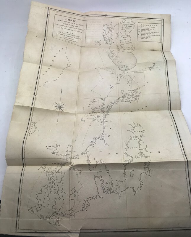
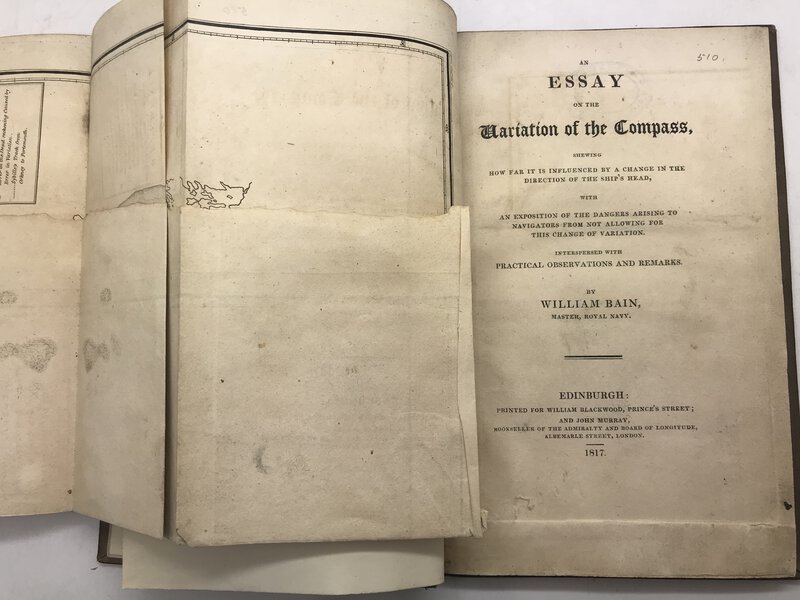
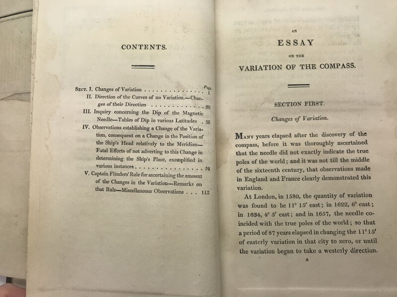
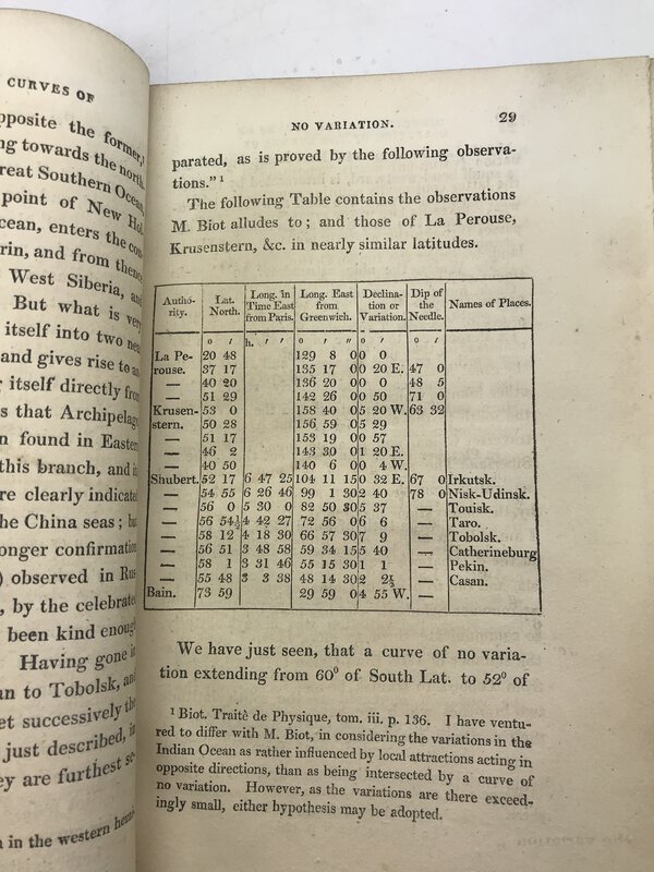
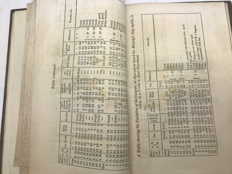
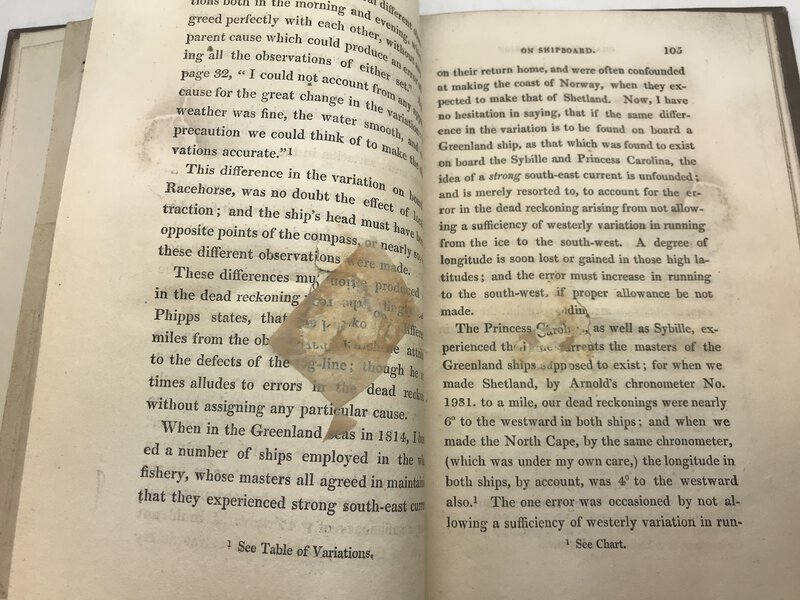
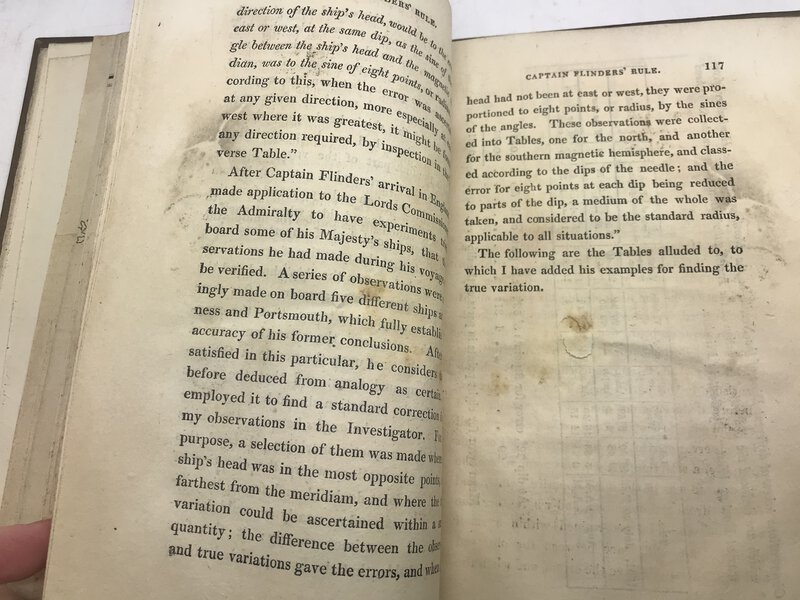
 An Essay on the Variation of the Compass,
shewing how far it is influenced by a change in the direction of the ship's head, with an exposition of the dangers arising to navigators from not allowing for this change of variation. Interspersed with Practical, Observations and Remarks.
Book ID: 2909More details Price: £85.00
An Essay on the Variation of the Compass,
shewing how far it is influenced by a change in the direction of the ship's head, with an exposition of the dangers arising to navigators from not allowing for this change of variation. Interspersed with Practical, Observations and Remarks.
Book ID: 2909More details Price: £85.00 -
 Asia
From Keith Johnston's General Atlas
Asia
From Keith Johnston's General Atlas
London: W & A.K. Johnston. A map of Asia, extracted from the General Atlas. This conforms best to the 1879 edition, except the lack of page title to the top edge, and the different page number. Engraved area is 13" x 17" (sheet is 141/2" x 181/2"). Lightly tipped onto mounting board, and now protected by archival protection. A lovely copy of this map from the height of colonial era.
Condition: A clean and tidy copy of this map. No significant damage at all. Clean and tidy, with the lightest of darkening.
Book ID: 1727More details Price: £15.00 -
 Atlas Géographique - Dressé sous la Direction du Conseil Royal de l'Instruction publique. Pour l'usage des Colléges.
1ère partie Géographiqe ancienne.
Book ID: 4054More details Price: £250.00
Atlas Géographique - Dressé sous la Direction du Conseil Royal de l'Instruction publique. Pour l'usage des Colléges.
1ère partie Géographiqe ancienne.
Book ID: 4054More details Price: £250.00 -
 Atlas Historique, Genealogique, Chronologique et Geographique.
Avec des augmentations par J. Marchal, de Bruxelles et de nombreuses ameliorations par une societe de savans et de gens de lettres.
Atlas Historique, Genealogique, Chronologique et Geographique.
Avec des augmentations par J. Marchal, de Bruxelles et de nombreuses ameliorations par une societe de savans et de gens de lettres.
Edition: First Thus
Book ID: 1918More details Price: £395.00 -
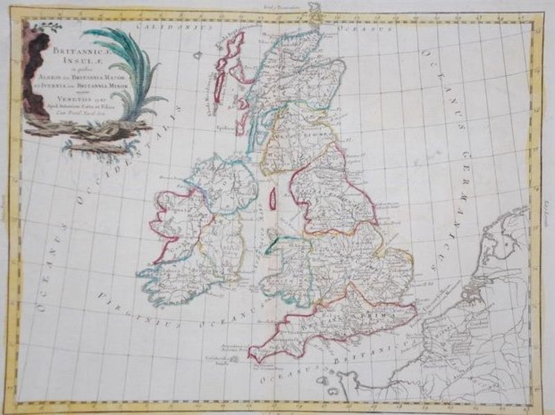
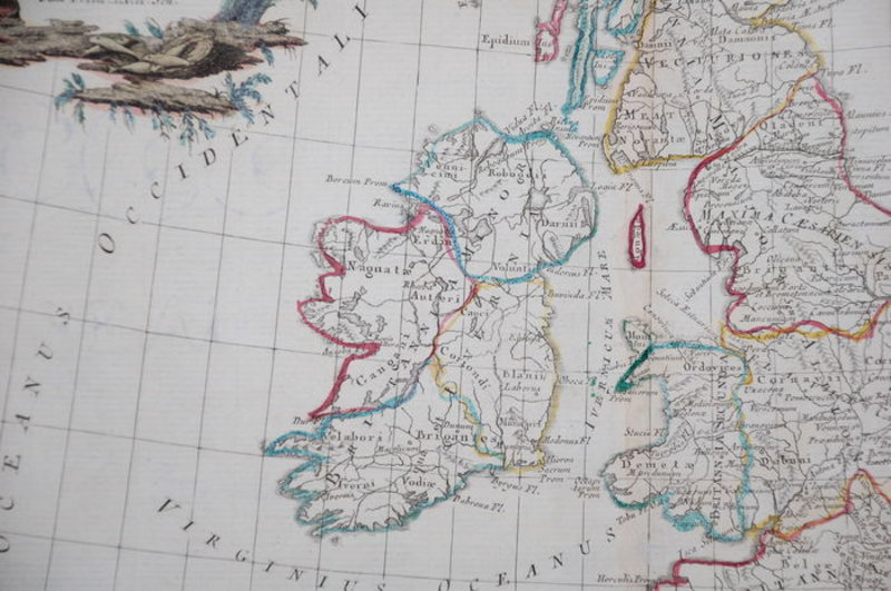
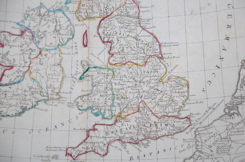
 Britannicae Insulae in quibus Albion Seu Britannia Major
Venitiis / Venice: Antonium Zatta, 1785. Hand-coloured map of Great Britain in good condition. Good. Wide margins. Fold as published. Slightly foxed in the margins. Imprint later hand colouring on verso. Verso: blank. 31 x 40 cm. From Zatta's Altante Novissimo, one of the last great decorative atlases of the 18th Century. Carte coloriée à la main de la Grande-Bretagne en bon état. Bon. De larges marges. Plier tel que publié. Légèrement rousseur dans les marges. Imprimez plus tard la coloration à la main au verso. Verso : vierge. 31x40cm. De l'Altante Novissimo de Zatta, l'un des derniers grands atlas décoratifs du XVIIIe siècle.
Book ID: 1783More details Price: £90.00 -
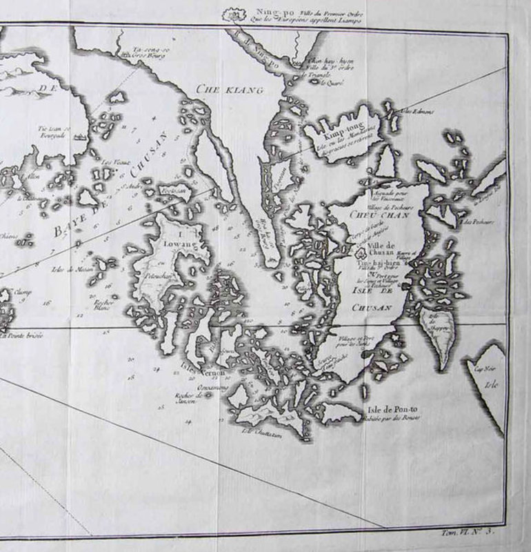
 Carte de l' Isle de Cheu-Chan ou Isle de Chusan de la Province de Che-Kiang
Avec les Costeset Isles voisines…
Book ID: 1788More details Price: £50.00
Carte de l' Isle de Cheu-Chan ou Isle de Chusan de la Province de Che-Kiang
Avec les Costeset Isles voisines…
Book ID: 1788More details Price: £50.00 -
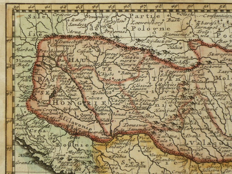
 Carte de la Hongrie
Paris: 1786. Hand coloured map of Hungary, published in Geographie Universelle. A touch darkened, with light staining to the verso. Folds where issued. A decent copy. 130 x 170 mm (5 x 6¾ inches). Carte coloriée à la main de la Hongrie, publiée dans Géographie Universelle. Une touche assombrie, avec légères taches au verso. Plis où émis. Une copie correcte. 130 x 170 mm.
Book ID: 1853More details Price: £55.00 -
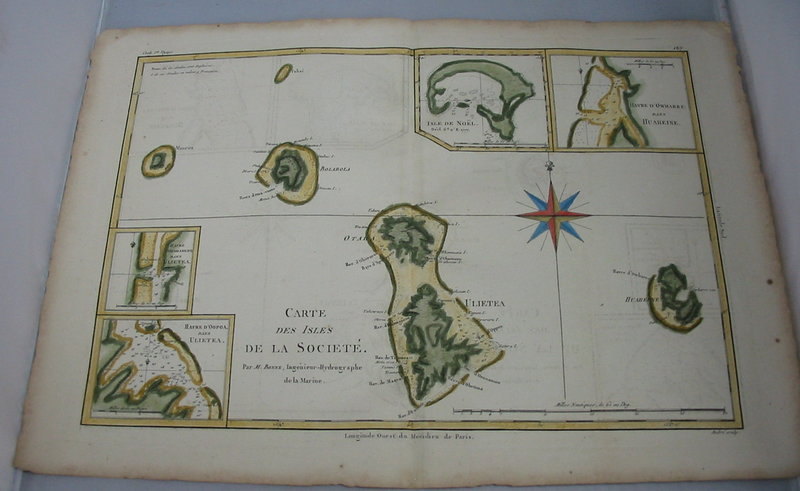
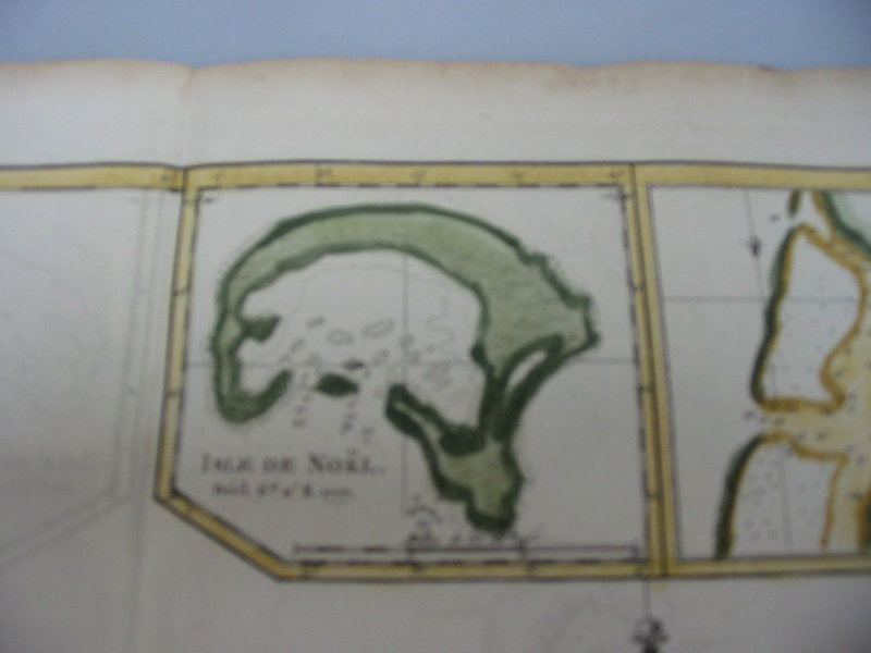
 Carte des isles de la Societé
Isle de Noël, Maurua, Tubai, Bolabola, Ulieta, Huaheine, Havre d'Oopoa, Havre d'Owharre.
Carte des isles de la Societé
Isle de Noël, Maurua, Tubai, Bolabola, Ulieta, Huaheine, Havre d'Oopoa, Havre d'Owharre.
Paris: Bonne: 1780. Copper engraving with hand colouring. Dimensions: 23 x 34 cm. Engraved by Andrei. States in the corner that this chart was part of Cooks 1st Voyage. A note engraved states (in French) that the islands are claimed by both the French and the English. Condition: very good, with a fold mark (as issued). 230 x 340 mm (9 x 13½ inches). Gravure sur cuivre avec coloration à la main. Dimensions : 23x34cm. Gravé par Andrei. Indique dans le coin que cette carte faisait partie du 1er voyage de Cooks. Une note gravée indique (en français) que les îles sont revendiquées à la fois par les Français et les Anglais. Condition : très bonne, avec une marque de pli (comme émis). 230 x 340 mm.
Book ID: 1806More details Price: £150.00 -
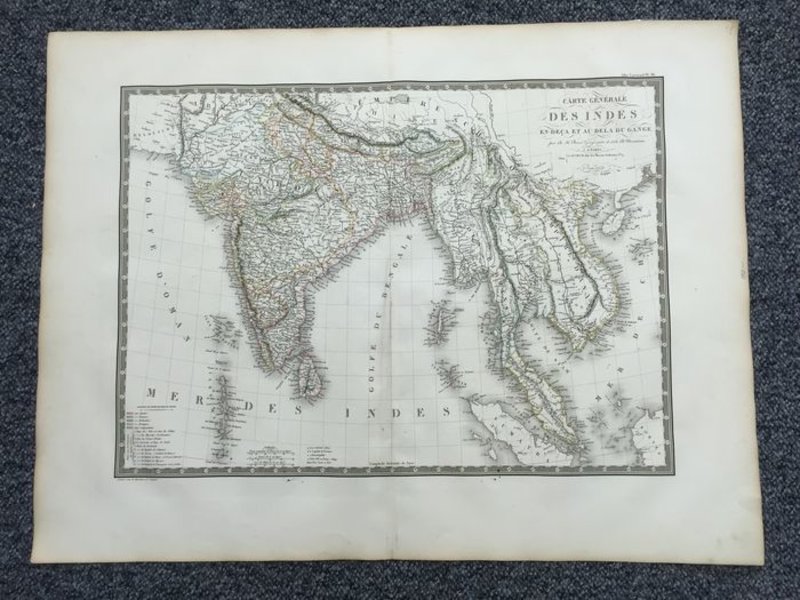
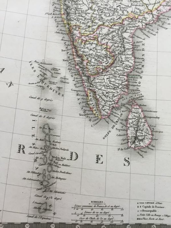
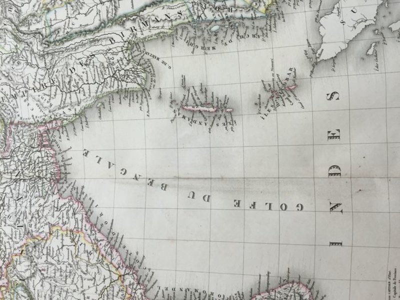
 Carte Générale Des Indes en-deca et au-dela du gange
Book ID: 1793More details Price: £60.00
Carte Générale Des Indes en-deca et au-dela du gange
Book ID: 1793More details Price: £60.00 -
 De Beurs - Hendrick de Keyser
Book ID: 4318More details Price: £200.00
De Beurs - Hendrick de Keyser
Book ID: 4318More details Price: £200.00 -
![Geographie Moderne: Barbarie/ Desert de Barbarie / Nigritie by CLOUET, J.B.L. [Jean, Baptiste, Louis. L'Abbe].](https://images.vialibri.net/production/20/1755-1---200.jpg?v=1531508298) Geographie Moderne: Barbarie/ Desert de Barbarie / Nigritie
A hand coloured map of the Sahara desert & North Africa - Also showing Southern Europe
Book ID: 1755More details Price: £85.00
Geographie Moderne: Barbarie/ Desert de Barbarie / Nigritie
A hand coloured map of the Sahara desert & North Africa - Also showing Southern Europe
Book ID: 1755More details Price: £85.00 -
![Geographie Moderne: De la Guinee / Du Congo / De la Cafrerie / Île de de Madagascar by CLOUET, J.B.L. [Jean, Baptiste, Louis. L'Abbe].](https://images.vialibri.net/production/20/1756-1---200.jpg?v=1531507725) Geographie Moderne: De la Guinee / Du Congo / De la Cafrerie / Île de de Madagascar
A hand coloured map of the African coast - Upper Guinea, Madagascar, the Gold Coast etc:
Book ID: 1756More details Price: £90.00
Geographie Moderne: De la Guinee / Du Congo / De la Cafrerie / Île de de Madagascar
A hand coloured map of the African coast - Upper Guinea, Madagascar, the Gold Coast etc:
Book ID: 1756More details Price: £90.00 -
![Geographie Moderne: Empire du Mogol / Siam / Cochin Chine & Camboja by CLOUET, J.B.L. [Jean, Baptiste, Louis. L'Abbe].](https://images.vialibri.net/production/20/1753-1---200.jpg?v=1531508852) Geographie Moderne: Empire du Mogol / Siam / Cochin Chine & Camboja
A hand coloured map of the Mogul Empire, India & South East Asia (Thailand & Vietnam).
Book ID: 1753More details Price: £90.00
Geographie Moderne: Empire du Mogol / Siam / Cochin Chine & Camboja
A hand coloured map of the Mogul Empire, India & South East Asia (Thailand & Vietnam).
Book ID: 1753More details Price: £90.00 -
![[GREAT BRITAIN] – HEDENDAAGSCHE HISTORIE, Of Tegenwoordige Staat Van Groot Brittannie. [Vol. I-II] by [SALMON, Thomas.] & TIRION, Isaak](https://images.vialibri.net/production/20/3701-01---200.jpg?v=1671543216) [GREAT BRITAIN] – HEDENDAAGSCHE HISTORIE, Of Tegenwoordige Staat Van Groot Brittannie. [Vol. I-II]
Vervattende Eene Beschryving van 's Lands Gelegenheid.
Book ID: 3701More details Price: £600.00
[GREAT BRITAIN] – HEDENDAAGSCHE HISTORIE, Of Tegenwoordige Staat Van Groot Brittannie. [Vol. I-II]
Vervattende Eene Beschryving van 's Lands Gelegenheid.
Book ID: 3701More details Price: £600.00 -
![[îles du Pacifique] by BONNE, Rigobert](https://images.vialibri.net/production/20/1805-1---200.JPG?v=1531510859) [îles du Pacifique]
Esquisse de la Baye Dusky dans la Nouvelle Zéelande. - Isles de Wallis. - I. Turtle. - I. des Cocos. I. des Traitres. - Palmerston I. - I. Sauvage. - I. d'Hervey. - I. des Pasques. - I. Pitcairn.
[îles du Pacifique]
Esquisse de la Baye Dusky dans la Nouvelle Zéelande. - Isles de Wallis. - I. Turtle. - I. des Cocos. I. des Traitres. - Palmerston I. - I. Sauvage. - I. d'Hervey. - I. des Pasques. - I. Pitcairn.
Paris: Bonne, 1780. Copper engraving with hand colouring. Condition: very good, with a fold mark (as issued). Dimensions: 230 x 340 mm. Gravure sur cuivre coloriée à la main. Condition : très bon, avec une marque de pli (comme publié). Dimensions : 230 x 340 mm.
Book ID: 1805More details Price: £80.00 -
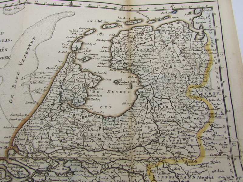
 Kaart van het gebied in het noorden van Nederland getroffen door de overstromingen in 1825.
Book ID: 2185More details Price: £120.00
Kaart van het gebied in het noorden van Nederland getroffen door de overstromingen in 1825.
Book ID: 2185More details Price: £120.00 -
 Kent
Kent
London: J. Cary, 1793. An engraved map of Kent, hand coloured in outline. The detail from Cary's atlas for Kent is visible and legible to the verso. Framed in a simple pale green mounting board. Protected by acid free plastic. John Cary worked from London as a mapmaker, engraver and publisher, towards the last quarter of the 18th century up to around 1830. His "New and Correct English Atlas", first published around 1776, was a benchmark in British topography. He used Copper plates for all his work, despite steel engraving becoming more common at this stage.
Condition: Very nice clean condition. There is fractional foxing to the edge of the written page (verso) the map itself is clean and tidy with the merest hint of darkening. A couple of tiny marks not affecting detail.
Book ID: 1279More details Price: £10.00 -
 L'Irlande suivant les Nouvelles Observations de Messrs. de l' Academie Royale des Sciences, etc.
Book ID: 1784More details Price: £180.00
L'Irlande suivant les Nouvelles Observations de Messrs. de l' Academie Royale des Sciences, etc.
Book ID: 1784More details Price: £180.00 -
 La Géographie Françoise contenant les Descriptions, les Cartes, et le Blason des Provinces de France.
Paris: Chez l'auteur, 1677. Scarce. Original full leather binding. Gilt decorations and title to spine. Marbled endpapers. Beautifully illustrated with a double-page engraved title and hand numbered double page table of contents. Contains 34 double-page engraved maps, mounted on tabs. Uncoloured. Boards are a little rubbed at edges, contents in very good condition. 165 x 110 mm (6½ x 4¼ inches).
. Rare. Reliure d'origine plein cuir. Décors dorés et titre au dos. Gardes marbrées. Magnifiquement illustré avec un titre gravé en double page et une table des matières en double page numérotée à la main. Contient 34 cartes gravées en double page, montées sur onglets. Incolore. Plats un peu frottés sur les bords, contenu en très bon état. 165 × 110 mm.
Book ID: 3856More details Price: £850.00


![Geographie Moderne: Barbarie/ Desert de Barbarie / Nigritie by CLOUET, J.B.L. [Jean, Baptiste, Louis. L'Abbe].](https://images.vialibri.net/production/20/1755-1---800.jpg?v=1531508298)
![Another image of Geographie Moderne: Barbarie/ Desert de Barbarie / Nigritie by CLOUET, J.B.L. [Jean, Baptiste, Louis. L'Abbe].](https://images.vialibri.net/production/20/1755-2---800.jpg?v=1531508180)
![Another image of Geographie Moderne: Barbarie/ Desert de Barbarie / Nigritie by CLOUET, J.B.L. [Jean, Baptiste, Louis. L'Abbe].](https://images.vialibri.net/production/20/1755-3---800.jpg?v=1531507724)
![Another image of Geographie Moderne: Barbarie/ Desert de Barbarie / Nigritie by CLOUET, J.B.L. [Jean, Baptiste, Louis. L'Abbe].](https://images.vialibri.net/production/20/1755-4---800.jpg?v=1531507930)
![Another image of Geographie Moderne: Barbarie/ Desert de Barbarie / Nigritie by CLOUET, J.B.L. [Jean, Baptiste, Louis. L'Abbe].](https://images.vialibri.net/production/20/1755-5---800.jpg?v=1531507977)
![Another image of Geographie Moderne: Barbarie/ Desert de Barbarie / Nigritie by CLOUET, J.B.L. [Jean, Baptiste, Louis. L'Abbe].](https://images.vialibri.net/production/20/1755-6---800.jpg?v=1531506565)
![Geographie Moderne: De la Guinee / Du Congo / De la Cafrerie / Île de de Madagascar by CLOUET, J.B.L. [Jean, Baptiste, Louis. L'Abbe].](https://images.vialibri.net/production/20/1756-1---800.jpg?v=1531507725)
![Another image of Geographie Moderne: De la Guinee / Du Congo / De la Cafrerie / Île de de Madagascar by CLOUET, J.B.L. [Jean, Baptiste, Louis. L'Abbe].](https://images.vialibri.net/production/20/1756-2---800.jpg?v=1531507584)
![Another image of Geographie Moderne: De la Guinee / Du Congo / De la Cafrerie / Île de de Madagascar by CLOUET, J.B.L. [Jean, Baptiste, Louis. L'Abbe].](https://images.vialibri.net/production/20/1756-3---800.jpg?v=1531507990)
![Another image of Geographie Moderne: De la Guinee / Du Congo / De la Cafrerie / Île de de Madagascar by CLOUET, J.B.L. [Jean, Baptiste, Louis. L'Abbe].](https://images.vialibri.net/production/20/1756-4---800.jpg?v=1531507792)
![Another image of Geographie Moderne: De la Guinee / Du Congo / De la Cafrerie / Île de de Madagascar by CLOUET, J.B.L. [Jean, Baptiste, Louis. L'Abbe].](https://images.vialibri.net/production/20/1756-5---800.jpg?v=1531507585)
![Another image of Geographie Moderne: De la Guinee / Du Congo / De la Cafrerie / Île de de Madagascar by CLOUET, J.B.L. [Jean, Baptiste, Louis. L'Abbe].](https://images.vialibri.net/production/20/1756-6---800.jpg?v=1531506567)
![Geographie Moderne: Empire du Mogol / Siam / Cochin Chine & Camboja by CLOUET, J.B.L. [Jean, Baptiste, Louis. L'Abbe].](https://images.vialibri.net/production/20/1753-1---800.jpg?v=1531508852)
![Another image of Geographie Moderne: Empire du Mogol / Siam / Cochin Chine & Camboja by CLOUET, J.B.L. [Jean, Baptiste, Louis. L'Abbe].](https://images.vialibri.net/production/20/1753-2---800.jpg?v=1531507976)
![Another image of Geographie Moderne: Empire du Mogol / Siam / Cochin Chine & Camboja by CLOUET, J.B.L. [Jean, Baptiste, Louis. L'Abbe].](https://images.vialibri.net/production/20/1753-3---800.jpg?v=1531506564)
![[GREAT BRITAIN] – HEDENDAAGSCHE HISTORIE, Of Tegenwoordige Staat Van Groot Brittannie. [Vol. I-II] by [SALMON, Thomas.] & TIRION, Isaak](https://images.vialibri.net/production/20/3701-01---800.jpg?v=1671543216)
![Another image of [GREAT BRITAIN] – HEDENDAAGSCHE HISTORIE, Of Tegenwoordige Staat Van Groot Brittannie. [Vol. I-II] by [SALMON, Thomas.] & TIRION, Isaak](https://images.vialibri.net/production/20/3701-02---800.jpg?v=1671543245)
![Another image of [GREAT BRITAIN] – HEDENDAAGSCHE HISTORIE, Of Tegenwoordige Staat Van Groot Brittannie. [Vol. I-II] by [SALMON, Thomas.] & TIRION, Isaak](https://images.vialibri.net/production/20/3701-03---800.jpg?v=1671543225)
![Another image of [GREAT BRITAIN] – HEDENDAAGSCHE HISTORIE, Of Tegenwoordige Staat Van Groot Brittannie. [Vol. I-II] by [SALMON, Thomas.] & TIRION, Isaak](https://images.vialibri.net/production/20/3701-04---800.jpg?v=1671543242)
![Another image of [GREAT BRITAIN] – HEDENDAAGSCHE HISTORIE, Of Tegenwoordige Staat Van Groot Brittannie. [Vol. I-II] by [SALMON, Thomas.] & TIRION, Isaak](https://images.vialibri.net/production/20/3701-05---800.jpg?v=1671543218)
![Another image of [GREAT BRITAIN] – HEDENDAAGSCHE HISTORIE, Of Tegenwoordige Staat Van Groot Brittannie. [Vol. I-II] by [SALMON, Thomas.] & TIRION, Isaak](https://images.vialibri.net/production/20/3701-06---800.jpg?v=1671543215)
![Another image of [GREAT BRITAIN] – HEDENDAAGSCHE HISTORIE, Of Tegenwoordige Staat Van Groot Brittannie. [Vol. I-II] by [SALMON, Thomas.] & TIRION, Isaak](https://images.vialibri.net/production/20/3701-07---800.jpg?v=1671543232)
![Another image of [GREAT BRITAIN] – HEDENDAAGSCHE HISTORIE, Of Tegenwoordige Staat Van Groot Brittannie. [Vol. I-II] by [SALMON, Thomas.] & TIRION, Isaak](https://images.vialibri.net/production/20/3701-08---800.jpg?v=1671543217)
![Another image of [GREAT BRITAIN] – HEDENDAAGSCHE HISTORIE, Of Tegenwoordige Staat Van Groot Brittannie. [Vol. I-II] by [SALMON, Thomas.] & TIRION, Isaak](https://images.vialibri.net/production/20/3701-09---800.jpg?v=1671543224)
![[îles du Pacifique] by BONNE, Rigobert](https://images.vialibri.net/production/20/1805-1---800.JPG?v=1531510859)
![Another image of [îles du Pacifique] by BONNE, Rigobert](https://images.vialibri.net/production/20/1805-2---800.JPG?v=1531510086)
![Another image of [îles du Pacifique] by BONNE, Rigobert](https://images.vialibri.net/production/20/1805-3---800.JPG?v=1531510203)
![Another image of [îles du Pacifique] by BONNE, Rigobert](https://images.vialibri.net/production/20/1805-4---800.JPG?v=1531510182)